|
|
|
|
| PROJECT: Brestovac |
Next project >> Deli Jovan |
|
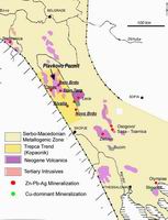
Background The Brestovac Exploration Permit is located within the central zone of the Timok Magmatic Complex, in the Serbian section of the East European Carpathian-Balkan Arc. Total metal endowment of the known ore deposits within the Bor�Majdanpek zone in the Timok Magmatic Complex, including current resources and past production, was estimated by Jankovic et al. (1998) to be over 20 Mt copper and 1,000 t gold. The Bor-Majdanpek mineralization is Cretaceous-age high-sulphidation epithermal and porphyry type copper-gold, with the main control the Bor fault that extends along the eastern side of the Timok Complex. The Brestovac Exploration Permit lies 5km south of the Bor copper-gold mine which has an endowment of 7 Mt of copper and 300 t of gold, of which current reserves and resources are over 200 Mt at 1.5% Cu and 0.8 g/t Au. Regional geophysics, geological mapping and satellite image analysis show that the Bor fault, which is the main control of mineralization in the region, passes through the Brestovac Exploration Permit. Reservoir filed a 43-101 Technical Report on the Brestovac Exploration Permit in January 2007. Geology and Mineralization The geology of the Permit area is dominated by Cretaceous andesitic volcanics and volcaniclastics, with very occasional shallow dacitic intrusives, overlain by Upper Cretaceous and Miocene sedimentary rocks. The Permit area is structurally complex, with both high-angle faults and thrust faults. Aster Image analysis demonstrates the structural continuity from the Bor copper-gold district southwards through the Brestovac Exploration Permit, as well as a circular structure � potentially a volcanic edifice � within the Exploration Permit. The Brestovac Sector of the Permit contains historic surface workings for gold (now obscured by vegetation), replacement zinc-copper-lead mineralization hosted by marls that was explored by an adit and blind shaft (no longer accessible), and occurrences of copper mineralization similar to the Bor-type and veins of quartz-pyrite-chalcopyrite-sphalerite mineralization. Drilling by Reservoir has identified high-grade epithermal gold mineralization predominantly associated with altered andesitic volcanics (pyroclastics). The controlling faults have been active for long periods of time, resulting in multiple phases of alteration, with gold mineralization a relatively late stage event. Title and Area The Brestovac Exploration Permit was originally issued in 2004 and has been renewed annually since then, based on approved annual reports and work programs. The Brestovac Exploration Permit covers 25.5 sq. km. The Zlot sector of the original permit has been relinquished. The adjacent ground is held by Euromax Resources Ltd (under the terms of an option agreement with Freeport McMoRan Copper and Gold Corp., and Dundee Precious Metals Inc. Exploration Status Initial work focused on validating the reported gold mineralization encountered in a 1970 drill hole near Brestovac. This included a drill hole in the same location as an earlier hole with reported gold and copper intercepts (BN-01). Concurrently geological mapping, stream sediment sampling, soil sampling, and rock-chip sampling from outcrops and float was undertaken, followed by detailed ground magnetic and IP/resistivity surveys. This work identified the �Corridor� of anomalous geochemistry and resistivity extending SW for about 300 meters from the gold mineralization discovered in drill hole BN-01. Epithermal Gold Mineralization in the Corridor The �Corridor� has been tested by 14 drill holes (total approximately 1,600 meters), all of which intersected gold mineralization and associated alteration, with best intercept of 16.90 meters at 13.04 g/t gold in BN-05 (see list of drill holes with analytical data of the best intersections in those holes assayed to date). In addition, carbonate replacement zinc mineralization was intersected in BN-01 - BN-05, BN-09, BN-11, BN-13 and BN-14. The gold mineralization is best developed (grade and thickness) in matrix-rich volcaniclastic rocks and hydrothermal and tectonic/fracture breccias, probably associated with high-angle faults. Alteration includes argillic and sericitic facies, with a carbonate overprint and local silicification, quartz veining and development of vuggy silica. Ore mineralogy is dominated by disseminated pyrite, accessory sphalerite and galena, and very rare free gold - electrum. Porphyry Copper-Gold Targets Bor-type Cu mineralization occurs in rock fragments outcropping in a quarry south of Brestovac village. Strong anomalies of Cu in soil sampling were contiguous with the dacite mapped south of Brestovac village, which is related to a prominent E-W structure, and close to the quarry outcrops containing fragments of Bor-type mineralization. Aster mineral mapping and structural interpretation demonstrated the structural continuity from the Bor porphyry district through the Brestovac Permit, as well as the presence of a circular structure around the known Cu occurrences. A deep-penetrating IP survey defined the presence of chargeability anomalies interpreted to be indicative of porphyry-style disseminated sulphide mineralization at depths of 200 � 400 meters in the target area. This target area, which borders to the south of the �Corridor� zone of epithermal mineralization, is considered to be highly prospective for porphyry copper and gold mineralization, and will be tested by drilling in 2008. Planned Work in 2008 The mineralization in the Corridor will be modeled in 3D. Additional drilling may be undertaken in order to provide sufficient information for an initial resource estimate. A deep drilling program (initially 1,700 meters) will test the porphyry copper-gold targets south of the �Corridor�. |
 Map of Timok Magmatic Complex with Brestovac Exploration Permit area 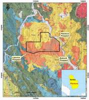 Brestovac Exploration Permit area, South of the Bor copper-gold mine, Eastern Serbia 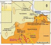 Mapped minerals and interpreted geologic structure from the Aster image 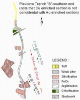 Geological Map of the Brestovac Area 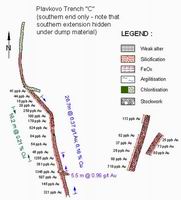 Slice 0-50m Inverted Resistivity Interpretation from the Corridor Area 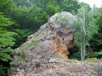 Pole Reduced Total Field Magnetic Survey Interpretation from the Corridor Area 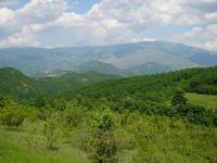 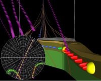 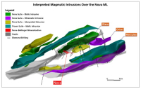 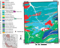  3D Visualization based on 20m intervals from Drilling Intercept data - within Corridor Area |